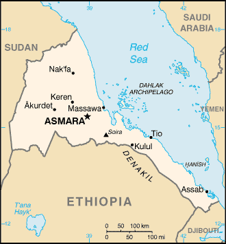
Map:

Overview:
Eritrea was awarded to Ethiopia in 1952 as part of a federation. Ethiopia's annexation of Eritrea as a province 10 years later sparked a 30-year struggle for independence that ended in 1991 with Eritrean rebels defeating governmental forces; independence was overwhelmingly approved in a 1993 referendum. A two-and-a-half-year border war with Ethiopia that erupted in 1998 ended under UN auspices on 12 December 2000. Eritrea currently hosts a UN peacekeeping operation that is monitoring a 25 km-wide Temporary Security Zone on the border with Ethiopia. An international commission, organized to resolve the border dispute, posted its findings in 2002 but final demarcation is on hold due to Ethiopian objections.
The People:
Population: 4,561,599 (July 2005 est.)
Age structure:
0-14 years: 44.8% (male 1,023,898/female 1,019,389)
15-64 years: 51.9% (male 1,170,823/female 1,194,741)
65 years and over: 3.3% (male 74,312/female 78,436) (2005 est.)
Religions:
Muslim, Coptic Christian, Roman Catholic, Protestant
Government Type:
transitional government
note: following a successful referendum on independence for the Autonomous Region of Eritrea on 23-25 April 1993, a National Assembly, composed entirely of the People's Front for Democracy and Justice or PFDJ, was established as a transitional legislature; a Constitutional Commission was also established to draft a constitution; ISAIAS Afworki was elected president by the transitional legislature; the constitution, ratified in May 1997, did not enter into effect, pending parliamentary and presidential elections; parliamentary elections had been scheduled in December 2001, but were postponed indefinitely; currently the sole legal party is the People's Front for Democracy and Justice (PFDJ)
Leader(s) to pray for:
chief of state: President ISAIAS Afworki (since 8 June 1993); note - the president is both the chief of state and head of government and is head of the State Council and National Assembly
Source: The World Factbook
View All Countries